
Itinerary, description of stages, practical informations, accomodation, GPS tracks of the way from Conques to Toulouse on the way to Santiago.
Conques to Toulouse
Superb unfrequented route. You will find historical places, rests of old pilgrimage routes and beautiful landscapes. Many parts are on small and wild country paths.
History : Peyrusse le Roc, Villeneuve d’Aveyron, Villefranche de Rouergue, Najac, Laguépie, Cordes, Gaillac, Rabastens and Toulouse.
Saint James remains : pilgrims hospices in Peyrusse le Roc, Villefranche, Najac, Cordes and Toulouse. Frescoes of Saint James and “hung man unhung” miracle in Villeneuve d’Aveyron. Capelette Saint James in Cordes. Frescoes in Rabastens (Unesco World Heritage). Saint Sernin and Saint James Hotel Dieu in Toulouse.
Landscapes : very green and hilly in the mining area, the Causse plateau and its characteristic flora, wild valley of the Aveyron, the Gaillac vineyards.
There is a guide book in french edited by the FFRP (French Federation of walking trails) for the itinerary Conques-Toulouse (available in libraries and online). I followed the GR until Cordes. From Gaillac to Rabastens, I opted for a more direct way along the Tarn river.
From le Puy to Conques : a very good guide to download with accommodation, tourist information … : Guidebook du Puy à Conques (in french).
Websites for Conques-Toulouse:
There is a guidebook of the French Federation of Hiking (FFRP – Fédération Française de Randonnée Pédestre).
For informations and accomodation, see the website of ACIR-Chemins de Compostelle.
Website dedicated to this way Conques-Toulouse with a lot of information both cultural and itinerary.
Website of the Association du Bas Rouergue vers Compostelle and Website of Les Amis de Saint Jacques en Occitanie with details of the stage to upload in pdf.
Website with GPS tracks and photos: Les balades et randos de Fred
Maps on the web:
France (maps of the Institut Géographique National) : http://www.geoportail.fr/ with Applestore application : Iphigénie http://iphigénie.com/?lang=en
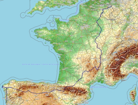
My way from Aachen to Santiago
Linked with the image below : the GPS track of all the hike (this GPS track has been remade after the hike)
My daily stages
| 1 | Conques – Cransac |
| 23km | Stage profile : On the shared way with GR65, steep way up after the pilgrim bridge in Conques. Then, if you go through Noailhac, there is 1km up to join Saint Roch chapel. After Firmi, series of slopes. |
| 6h | Notes : The way is well marked after leaving the GR65 : follow the GR62B to go down hill to Firmi. If you sleep in Cransac at the La Bastide du Puech, it will be 1km more (on the road to Bournazel) |
| Logistic : See above the link for pdf document to upload. The gite in Cransac was full, so I went to La Bastide du Puech Bed and Breakfast. Interesting pilgrim rate for the half board (34€) | |
| 2 | Cransac – Peyrusse le Roc |
| 20,5km | Stage profile : hilly at the beginning with the way up to Valzergues. Then quite flat except the arrival to Peyrusse le Roc. |
| 5h30 | Notes : From La Bastide du Puech Bed&Breakfast, I didn’t walked back to Cransac. I went through a nice way sometimes marked (PR – yellow marks) or in small roads via La Plantade, Le Moulin à Vent, Le Bac, Parpaillou, Le Cayla and the Croix de Campargue. It was 19km for the day stage with the detour by Valzergues. You can go straight but it’s a short detour and Valzergues village is beautiful. Nice walk all the day long with good views to hills and Plomb du Cantal mountain in the nortf. GR signs regularly. After Valzergues, there are less Saint-James shells so it can be confusing. Just trust the GR signs (red and white). |
| Logistic : See above the link for pdf document to upload. In addition, there is a boulangerie in Galgan. Peyrusse le Roc : Maison de l’Albine. | |
| 3 | Peyrusse le Roc – Villefranche de Rouergue |
| 30km | Stage profile : no difficulties. The way first goes down through the ruins of Peyrusse le Roc, then light way up to the Causse plateau. Just arriving in Villefranche, steeper way up. |
| 8h | Notes : To stop in Villeneuve makes a short day. Going to Villefranche makes a long day walking. On the other way, most of the walk is easy, especially on the Causse plateau. It’s nice to walk through the touching ruins (old church, the synagogue, pilgrim hospice, castle) of Peyrusse le Roc. In Villeneuve d’Aveyron, the paintings of pilgrimers, Saint-James and the “hung man unhung miracle” are worth the stop. Good signs during the day but I miss the turn off to the resurgence spring of la Diege. Before Villefranche, it is a bit more difficult to follow the sign. The last part is less interesting (suburbs of Villefranche). |
| Logistic : See above the link for pdf document to upload. In 2018, new hostel for pilgrims in Villeneuve d’Aveyron : la maison des Pèlerins. In Villefranche, the only low budget option is the gite d’etape of la Gasse. It is 2km more from city center. Hotel des Fleurines. | |
| 4 | Villefranche de Rouergue – Najac |
| 25km | Stage profile : 3 slopes above Aveyron valley. After Monteils, steep way up. The slope before Najac is more progressive and with shadow. Around 600 meter ascent for all the day. |
| 7h | Notes : Sign on the Causse plateau are less easy to see but you just have to go straight…Shadow on this part and in the Aveyron valley. |
| Logistic : See above the link for pdf document to upload. | |
| 5 | Najac – Cordes sur Ciel |
| 28km | Profil de l’étape : only one steep slope after the Saint Blaise bridge in Najac then, series of hills after Laguépie |
| 8h | Notes : Splendid day : walking through medieval streets of Najac passing in front of an old pilgrim hospice. Superb viewpoint to Najac from La Bastit. Nice path along the Aveyron river (why not try a refreshing bath?). Then up to Laguepie Castle. To finish, you will discover in front of you Cordes, the medieval city perched on it hill. You follow the GR36 signs all the day (but not many Santiago signs). |
| Logistic : See above the link for pdf document to upload. A new gite in 2013 : Gîte Ahuti, 12 Grand-rue de l’Horloge. 11€/night . Tel: 06 81 03 40 56. | |
| 6 | Cordes sur Ciel – Gaillac |
| 29km | Stage profile : nice hills at the beginning |
| 7h | Notes : Beautiful beginning with Cordes just behind you. After, you walk in Gaillac vineyards. The signs in Cahuzac can be confusing. I didn’t see any Saint James shells. |
| Logistic : See above the link for pdf document to upload. In addition for accomodation, Gaillac tourist office gave me 2 adresses : Dominican Old People Home – Maison de retraite des dominicaines (one room for pilgrims) – M and Mme Dawson (english family) – 29 rue Grande Côté – Tél : 0563572632 (4 beds, kitchen, donativo) | |
After Gaillac, the path goes along the foot of the hills to join Rabastens. I prefered to follow a more direct route closest to the Tarn river.
This path follows a more historical way (Old Road to Toulouse, Avens chapel where Charles the Bald, grandson of Carlomagno stopped, Lastours Castle, L’Isle sur Tarn and its old medieval houses, Castle Saint Gery).
By this way, it’s 18km to Rabastens instead of 27km with the GR.
It’s using paths and small roads with just two short sections of a busy road.
Itinerary : Quai Saint Jacques in Gaillac, path up at the end of the quay, then behind the supermarket, Gaillac airstrip, Avens Chapel, Castle Lastours, la Pissa, Foundapissa (with a piece of busy road between). L’Isle sur Tarn, Bramefan, Château de Saint Gery, Saint Amans, Rabastens.
