
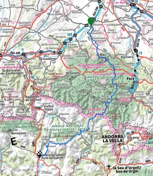
The way, accomodation, resupply, daily stages, GPS track of the hike through Pyrenees from Carbonne (along Garonne river, south of Toulouse) to Pont de Suert in Spain through Ariege and Aigüestortes national park.
From Garonne through Ariege and Aigüestortes national park
Another beautiful hike north-south through the Pyrenees with superb landscapes in popular and lesser known areas and via several historic places.
Like many of my north-south hikes in the Pyrenees, I started from the foot of the mountains to approach them slowly and gradually. It is also possible to start from Toulouse by the Via Garona.
From Carbonne, the way goes through Volvestre, an area with amazing views of the Pyrenees and beautiful villages (Rieux-Volvestre, Montesquieu-Volvestre, Montbrun-Bocage).
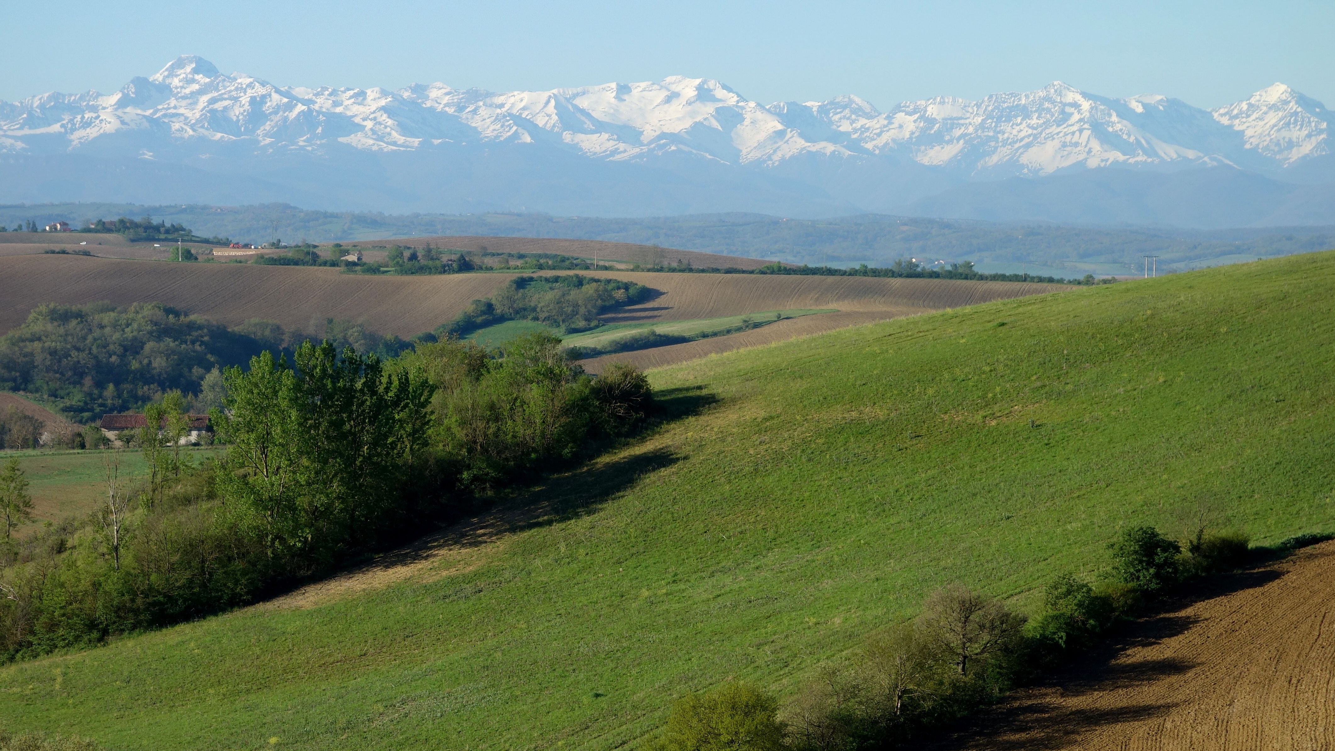
After the spectacular passage through the prehistoric cave of Mas d’Azil, the relief becomes more mountainous. The high peaks are getting closer.
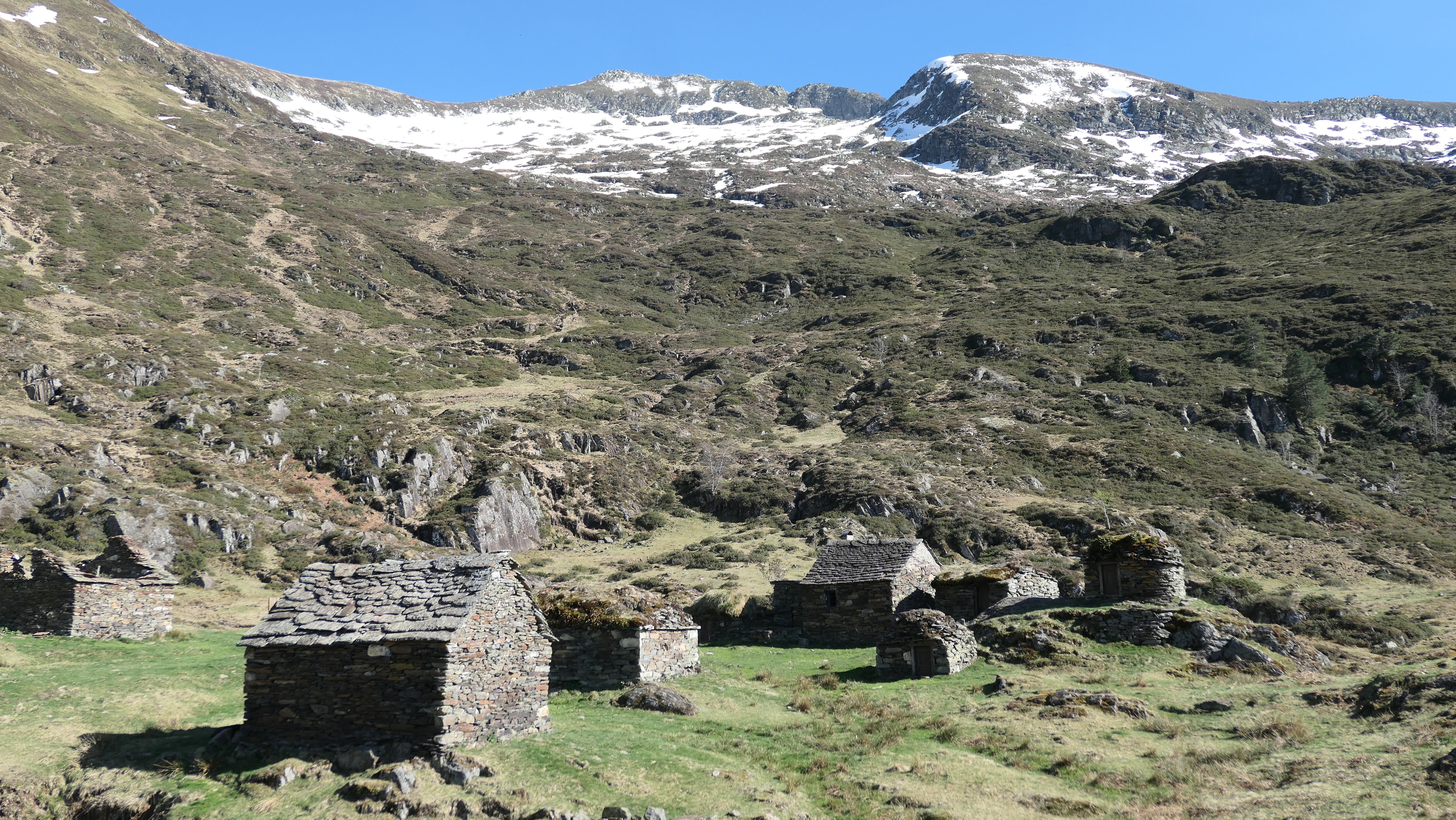
From Aulus, the way passes by the Ars waterfall then crosses the border via a little-used pass, the port of Sounou (or Guiló). On the Spanish side, to Guingueta d’Aneu, the path allows you to discover beautiful lake landscapes including those after Tavascan in a little-known valley.

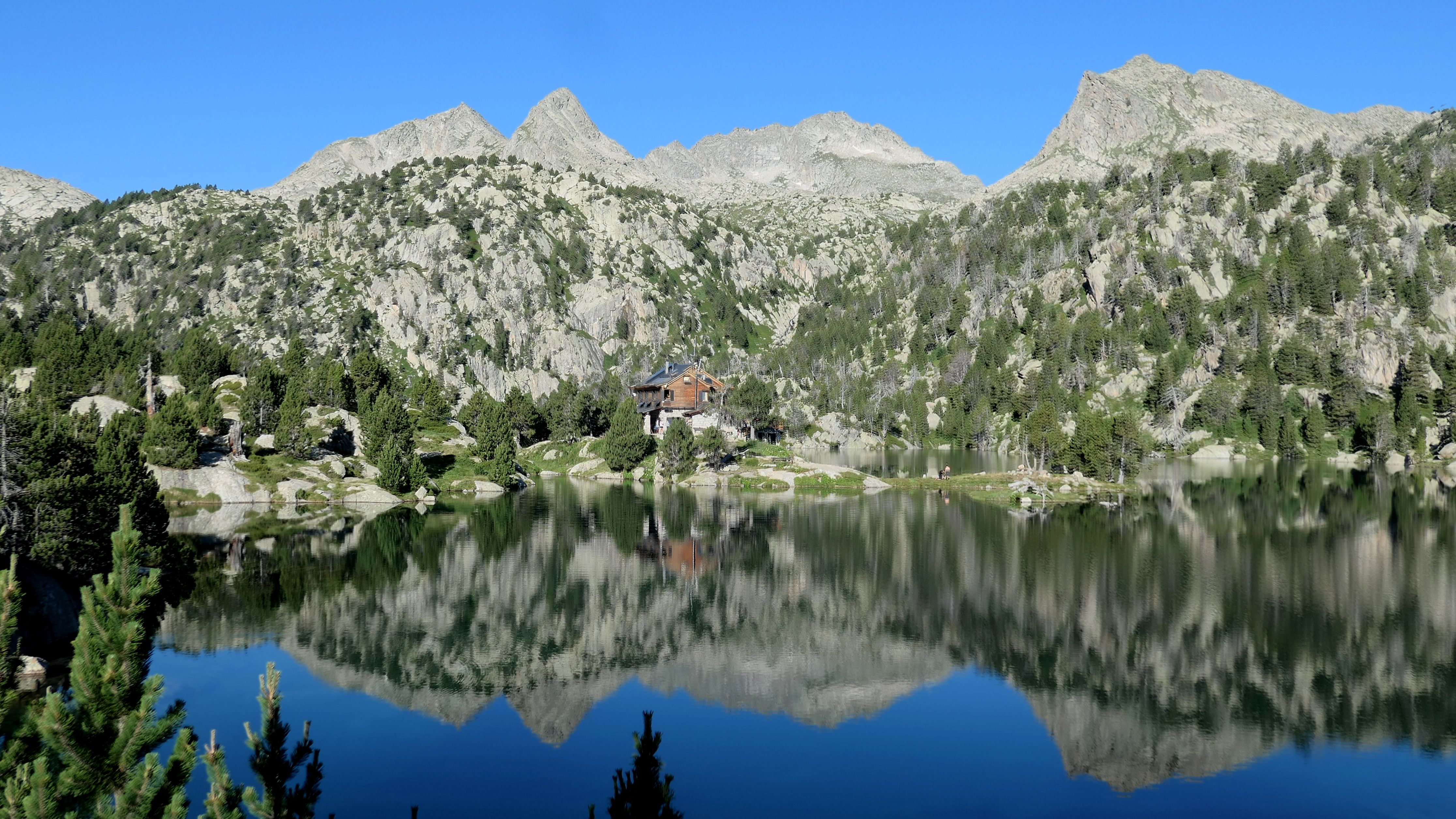
The hike through Aigüestortes National Park is superb via the enchanting site of Maria Blanc, before leaving the high mountains through the very isolated Manyanet valley.
Click for : the pictures from Carbonne to Pont de Suert
The others ways in Pyrenees described :
North-South trails on old cross-border paths, HRP, hike east-ouest entirely in Spain… are described in the page
See the page Hiking through Pyrenees

Useful information
Public transport :
It’s easy to go to Carbonne by train (Toulouse-Boussens-Tarbes line). To only hike the central part, take the bus from Boussens to Aulus-les-Bains via Saint-Girons.
During the summer period, buses from Pobla de Segur to Pont de Suert pass through Viu.
Barcelona-Vielha-Les buses pass via Pont de Suert with connection for bus line 395 from Les to Saint-Gaudens for return by train to the point of departure.
Difficulties :
It is a high mountain course with several passes above 2,500 meters in altitude, therefore with unstable weather and snowfields that can remain late in the season. The entire route is mostly on marked trails but in some parts the markings are light.
Trail marks :
Apart from some short parts, the whole route is on marked trails but sometimes these are only rare cairns. Being able to follow your GPS track will therefore be necessary.
Lexicon :
Bivouac: wild camping, usually according to French regulation, in a small tent (where you can’t standing) and pitched only for the night.
Abri: shelter. It’s unclosed (no door, some with just a roof) quite similar to those on the Appalachian Trail.
Cabane: small hut or shelter. It has a door. Some “cabanes” are occupied in summer by shepherds and open the rest of the year.
Refuge non gardé : unattended hut. Unlike a simple “cabane”, usually there are beds with mats.
Refuge: hut. You sleep in dorms, they can provide meals. Some of them even have showers.
Gîte d’étape: It’s like a refuge (or hostel) but accessible by road. You sleep in dorms (some have also bedrooms), they can provide meals. You will find “gîtes d’étape” on the main hiking trails.
Accomodation and resupply :
See the table below with my stages, shelters, refuges and shops.
Resupply : it is easy to resupply especially in the central part in Aulus-les-Bains and Espot.
Water : there is water frequently with fountains, springs and sometimes water from the river.
Accomodation : except after the Colomina refuge, it is possible to do the entire route without a tent by sleeping in hotels, hostels, refuges or cabins. From Colomina, possibility of continuing via the Boí valley with accommodation on the route. View page Cazères to Pont de Suert.
Bivouac : In the Aigüestortes y Estany de Sant Maurici National Park, bivouacs are prohibited, including next to shelters.
Internet websites :
For all France, the site gites-refuges.com is useful for information on huts and “gîtes d’étape” and that Refuges.info for huts and shelters.
Specifically for the Pyrenees, the site Pyrenees-refuges.com is very complete on this massif. It’s possible to download the gps position of all the “cabanes” and “refuges”.
In Spain, for information for huts see la central de refugis and the page for online reservations .
Website of Aigüestortes y Estany de Sant Maurici National Park
Maps :
For topographic maps of the French National Institute of Geography (IGN), see the website Geoportail.
With the website Brouter.de you can draw a GPS track following the existing ways and trails.
When I’m on my way, I’m using the Iphigénie application. With it, you can have offline IGN topographic maps (both for France and Spain). It’s also possible to send beacons of my position (if there is network); this can be reassuring on certain occasions.
GPS track :
For each stage, see important information below. Attention ! The trace below was redesigned when I get back. In all cases, the reality on the ground should be privileged. If passing through private land, ensure permission from the owner.
Link to download the GPS track:
The stages
| De Carbonne par l’Ariège | Km | Cumul km | D+ | Info |
| Carbonne | 0 | L’Ardoise Gourmande Tél.06 08 98 84 19 – commerces | ||
| Rieux-Volvestre | 10 | 10 | 370 | Camping du Plan d’Eau Tél.05 61 97 24 59 – commerces |
| Montesquieu-Volvestre | 6 | 16 | 130 | Maison Gaïa Tél.06 95 08 44 96 – Les chambres de Testory – commerces |
| La Bastide-de-Besplas | 8 | 24 | 220 | |
| Montbrun-Bocage | 5 | 29 | 120 | Le Nomade’s Land Tél.06 74 86 30 14/06 15 88 29 15 – Le Colibri Tél.+33 6 16 35 12 57 /+33 6 77 79 74 64 – épicerie |
| Notre-Dame de Montaut | 2 | 31 | 150 | Abri – source |
| 1 Carbonne – Notre-Dame de Montaut | Départ par la Via Garona puis chemins en partie balisés et petites routes. Belles vues sur les Pyrénées. 31km 1000m de dénivelés. | |||
| Mas d’Azil | 11 | 42 | 370 | Accueil pèlerins à l’église réformée Tél.05 61 69 90 46 (avec crédentiale) – Gîte Le Gardel Tél.+33 6 12 86 57 35 (chambre avec salle de bain 35€ avec petit déjeuner) – Gîte “Au fond de la ville” Tél.+33 661 77 61- commerces |
| La Bastide-de-Sérou | 15 | 57 | 720 | Camping L’Arize Tél.+33 0561658151 – commerces |
| Col des Marrous | 11 | 68 | 750 | Auberge Les Myrtilles Tél.+33 561651646 |
| 2 Notre-Dame de Montaut – Col de la Serre | Sentier balisé via les dolmens de Couminge et de Brillaud. Passage dans la grotte du Mas d’Azil puis chemin balisé jusqu’à la Bastide-de-Sérou. Piste pour rejoindre le col des Marrous. 39km 2000m de dénivelés. | |||
| Col de Port | 13 | 81 | 840 | Bar-restaurant – Cabane de la Canadelle |
| Col de Goulurs | 7 | 88 | 600 | Cabane |
| Goutets | 2 | 90 | 30 | Orris et cabanes (bergers en été) |
| 3 Col de la Serre – Goutets | Chemin balisé sur les crêtes. 20km 1300m de dénivelés. | |||
| Col de Rose | 3 | 93 | 240 | Cabane |
| Plateau de Coumebière | 8 | 101 | 390 | Cabane |
| Aulus-les-Bains | 4 | 105 | 10 | Gîte d’étape Le Presbytère Tél. 0768074107 – Camping Le Coulédous Tél.+33 561664356 – épicerie |
| 4 Goutets – Aulus-les-Bains | Sentier jusqu’au GR10 puis descente à Aulus-les-Bains. 16km 650m de dénivelés. | |||
| Cabane de la Hille de l’Étang | 7 | 112 | 990 | Cabane |
| Cabane du Troun d’Ars | 2 | 114 | 100 | Cabane |
| Refuge de Certascan | 7 | 121 | 830 | Refugi de Certascan Tél.+34 647 96 19 46 |
| Cabane de Guerossos | 5 | 126 | 400 | Cabane récente en bon état, poêle, filet d’eau à proximité. |
| 5 Aulus-les-Bains – Cabane de Guerossos | GR10 jusqu’au dessus de la cascade d’Ars puis sentier balisé pour passer la frontière au Port de Sounou (ou Guiló). À l’Estany Romedo de Dalt, on récupère le sentier des Porta del Cel via le refuge de Certascan. 22km 2300m de dénivelés. | |||
| Quanca | 4 | 130 | 0 | Camping Bordes de Graus – Tél.+34 973 62 32 46 |
| Tavascan | 2 | 132 | 320 | Refugi Pleta del Prat Tél.+34 615241414 |
| Estany de la Gola | 5 | 137 | 830 | Cabane. Il y a aussi un petit abri de pierre (mais avec toit récent) au bord de l’estany de Ventolau. |
| Unarre | 7 | 144 | 0 | |
| Escalarre | 2 | 146 | 10 | |
| Guingueta d’Àneu | 3 | 149 | 20 | Nou Càmping Tél.+34 973626261 – Camping Val d’Àneu Tél.+34 659104575 – Hotel Cases Tél.+34 648842278 |
| Espot (camping) | 7 | 156 | 540 | Càmping La Mola Tél.+34 651 03 45 27 – |
| Espot | 3 | 159 | 80 | Càmping Sol i Neu Tél.+34 973 62 40 01 – Càmping La Torre Tél.+34 973624160 – Hostal Casa Palmira Tél.+34 973083020 – commerces |
| 6 Cabane de Guerossos – Espot | Sentier jusqu’à Quanca. Pour éviter la route jusqu’à la station de ski de Tavascan, il est possible d’abord de prendre un ancien sentier (non balisé, un peu de végétation) puis après avoir traversé la route, on rejoint très vite un chemin balisé. De la station de ski sentier balisé avec cairns jusqu’au coll del Forn. Sur l’autre versant, sentier balisé jusqu’à la piste. On descend jusqu’à la Guingueta d’Aneu par des pistes et sentiers balisés (juste un peu de route vers Unarre). Ensuite GR11 jusqu’à Espot. 33km 1800m de dénivelés. | |||
| Refugi Josep Maria Blanc | 7 | 166 | 1 010 | Refugi Josep Maria Blanc Tél.+34 973 64 16 81 |
| Refugi Colomina | 7 | 173 | 445 | Refugi Colomina Tél.+34 973250118. Pour continuer en direction de la vallée de Boí, Voir la page Cazères to Pont-de-Suert. |
| 7 Espot – Au-dessus de Manyanet | Sentiers très fréquentés du Parc national d’Aigüestortes (GR11-20) puis avant le port de Rus, direction le port de Cabeçades. Le sentier n’apparaît pas sur les cartes mais le passage par ce port ne présente pas de difficultés. Le chemin n’est pas balisé mais on arrive à suivre des sentes. 32km 2460m de dénivelés. | |||
| Manyanet | 22 | 195 | 1020 | |
| Benés | 4 | 199 | 30 | |
| Viu | 11 | 210 | 460 | |
| 8 Au-dessus de Manyanet – Viu | Par la piste jusqu’à Benés (la fin est goudronnée) puis vague sentier pour monter au Coll de Sas ensuite par des pistes (sauf petit passage pour rejoindre la colline de Lo Faro). Arrivée à Viu par un sentier balisé. 18km 520m de dénivelés. | |||
| 210 | 210 | 12030 | ||
