
The way, accomodation, resupply, daily stages, GPS track of the Jordan Trail with before 3 days hiking in Sinai around Saint Catherine monastery.
Jordan Trail درب الأردن
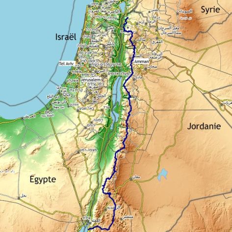
My way follows the Jordan Trail which connects the Gulf of Aqaba in the south to Um Qais near the Syrian border in the north with sometimes different options from the official route.
The Jordan Trail goes through major sites of the country. The south in the desert is fantastic with Wadi Rum, impressive canyons and Petra. The second part is wild with steep climbs and descents in deep wadis. Northern Jordan is more populated. There are more villages. Jordan Trail is sometimes on small roads. The vegetation is Mediterranean, very green and flowery at the end of winter and the way goes through several beautiful historical or biblical sites.
The Jordan Trail is not an easy path. It is only marked in the north. In the desert you have to carry enough water and sometimes you have to walk in the sand. The second part includes quite long sections in autonomy and there are elevation gains every day. Even the north has steep and challenging climbs.
In addition to superb landscapes and beautiful tourist sites, the Jordan Trail allows you to discover the hospitality of the Jordanians “Welcome to Jordan”.
For the daily story (in french), see the page Récit Jordan Trail
All the pictures
By clicking the image below :

Sinai around Saint Catherine
Some information to start in Sinai before the Jordan Trail
The circuit: I did a 3-day tour with the three main peaks around Sainte-Catherine: Mounts Moses, Sainte-Catherine (2630m highest point of Egypt) and Abbas. It is a beautiful circuit with historical and biblical places, peaks with vast panoramas and wadis with gardens and Bedouin houses. I slept both nights in Bedouin camps. My guide (see below) had arranged accommodation and food. For more information, see the board below.
Guides : it is mandatory to be accompanied by a guide. I did my tour with Juma جمعه عواد (Tel. +20 101 972 6782), a young Bedouin from Sainte-Catherine. I recommend him. He is very responsive on WhatsApp and knows how to adapt to your needs.
Paths : there are good trails, easy to follow.
Water : there is water quite regularly (during each passage through the wadis).
Network : Vodafone is the operator that covers Sainte-Catherine. There is a network regularly and particularly during passages at altitude and on summits.
Security : Islamist groups are present in northern Sinai and travel there is strictly discouraged. This does not include South Sinai and Saint Catherine which are in vigilance areas like the Nile Valley, Cairo. Check the update information about the situation at your embassy.
Gaz cartridge : see in Cairo, the Backpacker shop. I tried Amazon Egypt but a priori, they do not deliver gas cartridges to Sinai.
From the Red Sea to Saint Catherine : it’s possible to catch a minibus which connects Dahab or Nuweiba to Cairo and getting off at the junction 10 kilometers from the village. Otherwise taxi (around €40) from the seaside resorts.
Ferry Nuweiba-Aqaba : daily ferry.
Internet websites : see the website of Sinai Trail or the one of Little Nomad.
GPS track : Attention ! The GPS track has been made at my return. In all cases, the reality on the ground should be privileged. Link to download the track.
Internet websites
See the website of Jordan Trail with description of the stages, GPX tracks, list of accommodation, water points and sites to see. It is possible to download GPS tracks with POI (springs…). There is also an application which is not necessarily compatible with the latest Android versions.
See also the website of two youngs who hiked the Jordan Trail in 2018. Their website Thrujordan is very complete with possibility to download the complete pdf describing the path.
In Wadi Rum, there is a 120km circuit. The website Wadi Rum Trail provides information on this loop, which is best explored with a Bedouin guide.
For protected natural areas and accommodation inside those, see the website of the Royal Society for the Conservation of Nature (RSCN). Jordan Trail goes through Dana Biosphere Reserve, Mujib Biosphere Reserve and Ajloun Forest Reserve. Wadi Rum is a protected area but is not considered as a natural park.
Useful informations :
Resupply :
Water: obviously a primordial question in the desert. I made my stages in order to sleep each night with water nearby. This significantly reduces the amount of water to carry but it led me to do some long stages. Since it wasn’t hot, I never carried more than 4 liters. See the table below and the website Jordan Trail.
Food: there are grocery stores quite regularly. In the smaller ones, you will find basic foods like cans of sardines, meat, feta in Tetra Pack (very convenient), all kinds of biscuits and sweets. It is quite common to find Chinese noodles. See the table below.
Gas canister : In Amman, the Trek Shop sells screw in gas cartridges. I ordered via their website with delivery to my hotel in Aqaba.
Accomodation : In tourist places where there is more possibilities, you can find half-board accommodation for around €35. Elsewhere, it’s more around €50.
Bivouac : in the south, it’s easy to bivouac almost everywhere except in the natural reserve of Dana where it’s forbidden. On the other hand, in places where there is water, there are often nomads with herds and dogs. In the north, you have to look for isolated places. Be careful, in exposed high places, the wind is sometimes violent and do not camp near the wadis in case of rain. The water rises at an impressive speed.
Network : I bought a SIM card from Orange Jordan. I had network at least once every day and almost constantly in the north. I feel like Zain has better coverage (in the desert, sometimes Orange didn’t get through but Zain did). Jordanians told me that, on the contrary, the Orange network was more efficient.
Near the border, I received the Israeli network which is included with certain Western operators.
Trail marks : the Jordan Trail is marked in the north, sometimes well enough to be guided. In the south, there are sometimes cairns. In any case, you will need to have a GPS track to guide you (in 2024, GPS was jammed near the Israeli border, which complicated navigation).
Weather : I walked from mid-February to mid-March. It was pretty cold and I didn’t have hot temperatures. It was ideal for walking. I had some rain in the desert and more frequently in the north.
Security :
Check the update information about the situation at your embassy.
Dangers :
Fauna : the snakes are little or not present in winter, the same for scorpions. There are a lot of dogs. I found them less aggressive than in Albania, Romania or Türkiye. They bark, approach but keep a certain distance, especially if you have stones in your hand (or if you pretend to have them).
Wadis: the water rises very quickly in the event of rain. Avoid going through wadis if the forecast is bad.
Waste: as in many developing countries, waste litters in the countryside and the more it is popular, the more there is.
Communication : apart from services intended for tourists, the use of English is limited to basic words and formulas. A little Arabic will help you in your communications.
Payments: Most of the time, payments are made in cash. There are ATMs quite regularly. Withdrawal fees vary greatly from one bank to another (sometimes up to €8 in bank commissions).
Jordan Pass: it is interesting to buy a Jordan Pass. This must be done before leaving. It includes visa fees on arrival and entry to many sites including Petra. Valid 15 days after the first validation of entry into a site, it will be necessary to calculate so that Petra, the most expensive site, falls within this period (but it seems not to be checked).
Equipment : Compared to my usual equipment, I added some elements to improve autonomy: a solar panel a little more powerful than the Tomshine, an adapter for valve gas cartridge (CV or Easy Click from Camping Gaz) and a filter bottle Katadyn BeFree 0.6l. My base weight without water and food is approaching 7.9kg.

Maps :
To draw a track, the website Brouter.de (see video) allows to draw following the existing ways and trails.
When I’m on my way, I’m using the Iphigénie application with for Jordan the OpenCycleMap base map which has the advantage of having the names of the places in Latin and Arabic alphabet.
The application Mapy.cz is great. The maps are with Latin and Arabic characters. It is possible to download the maps to have access offline.
GPS track :
It’s mostly based on Jordan Trail but with sometimes different options. Attention ! The GPS track below has been made at my return. In all cases, the reality on the ground should be privileged.
Link to download the GPX track :
Sinai around Saint Catherine
| Sinaï – Ste Catherine | Km | Cumul km | D+ | Info |
| Sainte-Catherine دير سانت كاترين | 0 | Monastère Sainte-Catherine Tél.+20 69 3470 353 – Sheikh Mousa Camp Tél.+201006413575 | ||
| Mont Sinaï جبل موسى | 8 | 8 | 870 | Boissons, snacks et souvenirs au sommet. |
| Deir al-Arbain دير الأربعين | 3 | 11 | 120 | Jardin de Ramadan (possibilité hébergement et restauration) |
| 1 Sainte Catherine – Deir al-Arbain | Montée directement du village. Bons sentiers mais montée assez directe en partie avec escaliers. Puit dans le wadi en montant puis sur le replat à 2000m d’altitude. 11km 990m de denivelés. | |||
| Mont Sainte-Catherine جبل كاترين | 7 | 18 | 920 | |
| Wadi Zawatin | 7 | 25 | 150 | |
| 2 Deir al-Arbain – Wadi Zawatin | Bons sentiers (assez raides). De l’eau dans le Wadi Zawatin. Possibilité de dormir à Umm Saad garden. 14km 1070m de dénivelés. | |||
| Abbas Mountain جبل عباس | 3 | 28 | 420 | |
| Wadi Tinya | 3 | 31 | 50 | Eau |
| Karazet al-Shaq | 3 | 34 | 60 | Eau |
| Wadi Itlah | 4 | 38 | 170 | Eau – camps |
| Sainte Catherine سانت كاترين | 4 | 42 | 280 | Sheikh Mousa Camp Tél.+201006413575 |
| 3 Wadi Zawatin – Sainte-Catherine | Bons sentiers avec un passage raide à Karazet al-Shaq. Des puits dans les wadis. 17km 990m de dénivelés. | |||
| 42 | 42 | 3 040 | ||
The stages of Jordan Trail
| Jordan Trail | Km | Cumul km | D+ | Info |
| Aqaba (Tala Bay) العقبة | 0 | Arab Divers Tél.+962 796412032 – Bedouin Garden Village Tél.+962 795602521 – Bait Al Aqaba resort Tél.+962 799944797 – Red Sea Dive Center Tél.+962 32018969 | ||
| Camp | 18 | 18 | 1 250 | Ali Zalabiah Tél.+962 776558752 |
| Campement bédouins | 3 | 21 | 0 | Puits (de l’eau en février 2024) |
| Titen تتن | 9 | 30 | 220 | Petite épicerie (produits de base) – possibilité de chambre (eau et électricité) : voir avec l’épicier – réseau avec Zain |
| 4 Aqaba (Tala Bay ) – Titen | Pas de difficultés particulières. Le chemin se suit facilement, le plus souvent dans les lits asséchés de wadis avec juste les passages des cols sur sentiers plus rocailleux (quelques cairns). J’ai pris quelques petits raccourcis. 30km 1470m de dénivelés. | |||
| Wadi Waraqa | 13 | 43 | 380 | Suleiman Al Zalabieh Tél.+962 795902127 – des citernes d’eau 3km avant Wadi Waraqa juste avant le passage par le point haut et juste après. Eau aussi après sur le versant est du Jebel dans une faille (idem sur la faille du Jebel en face) |
| Qattar spring عين القطار | 12 | 55 | 210 | De l’eau à la source – Alqatar Camp Tél.+962 772733808 – Gamra Eco-camp Tél. |
| Djebel Khazali جبل الخزعلي | 4 | 59 | 30 | Wadi Rum Camp – Tél.+962 776409977 |
| 5 Titen – Jebel Khazali | Chemin le plus souvent sur des pistes ou en parallèle (pour éviter le sol sablonneux). Plus de sable après Wadi Waraqa. Paysages superbes du Wadi Rum. 28km 650m de dénivelés. | |||
| Wadi Rum (village) وادي رم | 5 | 64 | 10 | Climbers’ House Tél.+962 777975585 – Wadi Rum Hostel Tél.+962 772696039 – épicerie |
| Shakaria Camp | 11 | 75 | 50 | Shakria camp Tél.+962 779747493 |
| 6 Jebel Khazali – Shakaria | Petit détour par le Siq Khazali. Après le village de Rum, je suis passé à l’est du wadi pour éviter la route. Toujours de belles vues. 17km 80m de dénivelés. | |||
| Shakaria الشاكرية | 4 | 79 | 30 | Ali Tél.+962 772733808 – Beit Ali Lodge Camp Tél.+962 795548133 – Jabal Rum Camp Tél.+962 778669933 – épicerie |
| Jabal Kharazah | 15 | 94 | 150 | Yousef Al Mousah Tél.+962 777283309 – Sabah Al Manajaa Tél. +962 778377254 – citerne djebel à l’est |
| Humeima (village) الحميمة | 13 | 107 | 150 | Commerces |
| 7 Shakaria – Humeima | Longue étape dans des immensités désertiques et toujours de fabuleux paysages. Il suffit de se fixer un cap et d’aller tout droit. 32km 360m de dénivelés. | |||
| Humeima (visitor center) | 9 | 116 | 100 | Yousef Al Mousah Tél.+962 777283309 – Sabah Al Manajaa Tél. +962 778377254 |
| Abbasiya العباسية | 4 | 120 | 70 | Abu Sabah Tél.+962 7 9631 8709 – eau |
| Ain Aheimar | 10 | 130 | 240 | J’ai eu un peu de mal à trouver la source. Il y a une plateforme sableuse visiblement utilisée pour camper. Un peu en amont (200m), en remontant côté sud un canyon étroit, j’ai trouvé de l’eau. |
| Wadi Aheimar وادي أحيمر | 11 | 141 | 240 | Eid Al Managa’h Tél.+962 796318709 – pas d’eau qui coule même après les pluies des derniers jours. |
| Wadi Rakiya | 6 | 147 | 160 | Campements bédouins – Pas d’eau mais on peut demander. |
| 8 Humeima – Wadi Waraqa | Tout droit jusqu’aux ruines de Humeima puis piste jusqu’à Abbasiya. La descente vers le Wadi Aheimar est facile à suivre. Le canyon est spectaculaire. Parfois quelques cairns. 41km 810m de dénivelés. | |||
| Wadi Gseib | 7 | 154 | 220 | Ali Saideen Tél.+962 777049506 |
| Wadi al-Saif | 12 | 166 | 430 | |
| Ain al-O’Rouq | 10 | 179 | 200 | Source. L’eau coule au ras du sable. Sur quelques kilomètres en aval mince filet d’eau. |
| 9 Wadi Waraqa – Ain al-O’Rouq | Remontée dans le canyon. Avant le col, passer un peu en hauteur rive droite (suivre cairns). Bon sentier à la descente (souvent en hauteur rive gauche). Remontée du Wadi Gseib dans le lit puis avant un plateau, très en hauteur rive gauche (cairns, bon sentier). Ensuite piste 4*4 qui passe le col et descend le Wadi al-Saif. Pour rejoindre le Wadi Abu O’Rouq, c’est un peu un labyrinthe pour passer de canyon en canyon. Bien suivre la trace. 29km 850m de dénivelés. | |||
| Gaa’Mriebed | 3 | 179 | 130 | Mahmoud Abdulsalam (Habu) Tél.+962 778332061 – camps bédouins. |
| Wadi Sabra | 10 | 189 | 370 | De l’eau coulait dans la partie basse puis en haut vers le palmier avant le théâtre. Camps bédouins après le théâtre. |
| Petra – Wadi Musa وادي موسى | 12 | 201 | 620 | Hostel Rafiki Tél.+962 3 2156 777 – Hotel Nomads Tél.+962 32157171 – Hotel Casablanca Tél.+962 776493345 – Petra Cabin Hostel Tél.+962 775538696 – Tous services |
| 10 Ain al-O’Rouq – Pétra (Wadi Musa) | Remontée du Wadi Abu O’Rouq puis après Gaa’ Mriebed descente dans le Wadi Sabra. On suit le lit mais il ne faut pas louper le passage où on quitte le lit pour remonter côté nord (cairns, suivre la trace). On redescend ensuite retrouver le wadi. Passage à Pétra par le Haut Lieu du Sacrifice puis par le Siq. 25km 1100m de dénivelés. | |||
| Petra | 3 | 204 | 90 | Bars-restaurants |
| Little Petra | 10 | 214 | 580 | Abdallah Ammarin Tél.+962 775945592 – Plusieurs camps – bars – restaurants |
| Rock Camp | 7 | 221 | 190 | Rock Camp Tél.+962 7 7663 3023 |
| Qbour al-Wahdat | 2 | 223 | 50 | Namla Bedouin camp Tél.+962 776671645 – guesthouse ? |
| 11 Pétra (Wadi Musa) – Qbour al-Wahdat | Traversée de Pétra puis chemin jusqu’à Little Pétra. Ensuite bon sentier ou piste avec de nombreuses tentes de Bédouins et quelques cultures . 22km 920m de dénivelés. | |||
| Qutla | 7 | 230 | 310 | Pas vu de source. Seulement une poche réservoir d’eau |
| Ras Al-Feid | 5 | 235 | 110 | Eid Azazmeh Tél.+962 779265511 |
| Wadi Al-Feid | 2 | 237 | 30 | Le wadi coulait avec un bon débit |
| Wadi Al-Malaqa | 11 | 248 | 320 | Mohammad Zannoun Tél.+962 788898675 – Ali Hsaseen Tél.+962 772420021 – pas d’eau – Village de Feynan à 3km |
| Wadi Ghwayr | 6 | 254 | 70 | Wadi Al Ghwer Camp Tél.+962 776197010 |
| 12 Qbour al-Wahdat – Wadi Ghwayr | Sentier très agréable en hauteur et beaux panoramas. Des cairns et même quelques flèches peintes à un endroit. Descente dans le wadi Feid. Bon sentier pour passer le col Ras Naqb Shdeid. Ensuite longue et ennuyeuse traversée à flanc dans des pierriers avec des successions de montées et descentes pour franchir les lits des rivières. 31km 890m de dénivelés. | |||
| Feynan Ecolodge | 2 | 256 | 80 | Feynan Ecolodge Tél.+962 65850333 |
| Dana ضانا | 13 | 269 | 980 | Dana Biosphere Reserve Tél.+962 7 9911 1434 – Dana Tower Hotel Tél.+962 7 9568 8853 – petite épicerie |
| 13 Wadi Ghwayr – Dana | Remontée du wadi. Quelques filets d’eau (beaucoup de troupeaux et je n’ai pas vu de source). Belle grimpette à la fin. 15km 1060m de dénivelés | |||
| Buṣeirah بصيرا | 8 | 277 | 320 | Commerces |
| Matan المعطن | 7 | 284 | 430 | Mattan Heritage Village Tél.+962 799786864 – Qusai AlShabatat Tél.+962 799786864 |
| Ain Al Beda البيضاء الكبير | 2 | 286 | 190 | Commerces |
| Al Aïs العيص | 11 | 297 | 360 | Faris Hotel Tél.+962 796013000 – Commerces |
| 14 Dana – Al Aïs (Tafilah) | Je suis passé par Buṣeirah pour me réapprovisionner. Bonne descente vers le wadi Al Hamaidah et remontée ensuite vers El Matan. Globalement peu de bitume dans la journée. Des cairns parfois mais la trace GPS est bien utile avec les nombreux chemins et sentiers dans la campagne. 28km 1290m de dénivelés. | |||
| Burbeita – Wadi Al-Hassa | 20 | 317 | 90 | Wadi Al Hasa camp Tél.+962 798447971 – Sail Al-Hassa Tél. |
| 15 Al Aïs (Tafilah) – Burbeita (Wadi Al-Hassa) | À peu près la moitié de l’étape sur petites routes en altitude. L’autre moitié sur piste puis sentier à la fin qu’il faut deviner. 20km 90m de dénivelés. | |||
| Tor Taboun | 6 | 323 | 650 | |
| Khresha الخريشا | 3 | 326 | 390 | Fog Mountain Tél. |
| Kérak الكرك | 23 | 349 | 690 | The Old House Tél.+962 795170201 – Beit Al Karam Tél.+962 7 9837 2030 – commerces |
| 16 Burbeita (Wadi Al-Hassa) – Kérak | Bonne remontée jusqu’au plateau. Ensuite essentiellement des chemins dans la campagne. 32km 1750m de dénivelés. | |||
| Rakin راكين | 7 | 356 | 420 | Épicerie – bar |
| Rabba الربة | 6 | 362 | 40 | Al-Karak Countryside Hotel Tél.+962 795383639 – commerces |
| Al Yarout الياروت – Al-Qasr القصر | 4 | 366 | 20 | Commerces |
| Majdaleen مجدلين | 4 | 370 | 50 | Huthaifa Shamayleh Tél.+962 798372030 – Mohammad Bashabsheh Tél.+962 791534734 |
| Faqqu’ فقوع | 4 | 374 | 30 | Commerces |
| Jardins | 9 | 383 | 60 | Source |
| Camp | 2 | 385 | 70 | Ruisseau |
| 17 Kérak – Wadi Mujib | Chemin dans un vallon encaissé puis remontée sur le plateau. Chemin droit et plat de Rakin à Faqqu (route après Rabba). Petit détour par Rabba et Faqqu. Le sentier qui descend dans le Wadi Mujib est bon. Variante vers la fin. 37km 720m de dénivelés. | |||
| Wadi Mujib | 4 | 389 | 180 | Le wadi coule bien. Saleh Alziadin Tél.+962 777248449 – sources 3km après |
| Wadi Hidan | 12 | 401 | 970 | Le wadi coule bien. Saleh Alhomran Tél.+962 776840606 – Source aïn dafali 2km avant et aïn Jardela 1km après |
| Al Arid – Bani Hamida بني حميدة | 9 | 410 | 770 | Épicerie |
| Wadi Zarqa Ma’in | 8 | 418 | 130 | Le wadi coule bien |
| 18 Wadi Mujib – Wadi Zarqa Ma’in | Journée à monter et descendre des wadis avec la remontée du Wadi Mujib, le Wadi Hidan et descente dans le Wadi Zarqa Ma’in. Globalement bons sentiers. 33km 2020m de dénivelés. | |||
| Wadi Himara وادي حمارة | 8 | 426 | 380 | Maisons |
| Oyoon Al-Theeb Wadi al Mukhayris وادي المخيرص | 12 | 438 | 310 | Maisons – jardins – Jaafar al Snayyan Tél.+962 777403598 |
| Knaiseh | 9 | 447 | 510 | Source (l’eau coulait) |
| Mont Nébo جبل نيبو | 3 | 450 | 400 | Restaurants |
| Source de Moïse عيون موسى | 2 | 452 | 20 | Elle coulait avec un bon débit |
| 19 Wadi Zarqa Ma’in – Source de Moïse | Bon sentier pour monter au-dessus du wadi. Variante après Oyoon Al-Theeb. La trace pour monter au mont Nébo ne me paraît pas bonne. J’ai modifié la mienne. 34km 1640m de dénivelés. | |||
| Husban حسبان | 4 | 456 | 390 | Mohammad AlBarari Tél.+962 795097211 |
| Adassiyah العدسية | 10 | 466 | 390 | Commerces – restaurants |
| Iraq al-Amir عراق الأمير | 7 | 473 | 380 | Women’s Cooperative Guesthouse Tél.+962 777351620 – épiceries |
| 20 Source de Moïse – Iraq Al Amir | Étape dans la campagne avec essentiellement des chemins. Peu de bitume. Quelques variantes par rapport au Jordan Trail. Parfois de vieilles marques rouge et blanc type GR. 21km 970m de dénivelés | |||
| Bader Al Jadeedah بدر الجديدة | 4 | 477 | 260 | Bars |
| Salt السلط | 18 | 495 | 990 | Jordan Heritage Madhafa Tél.+962 7 77733033 – Beit Aziz Tél.+962 799436969 – Tous commerces |
| 21 Iraq Al Amir – Salt | J’ai finalement choisit l’option du Jordan Trail par Salt. Étape essentiellement sur des petites routes (hormis le sentier dans le beau vallon avant Salt). Quelques pentes bien raides. Balisage rouge et blanc assez régulier. 22km 1250m de dénivelés. | |||
| Rmemeen الرميمين | 15 | 510 | 460 | Commerces – bar |
| King Talal Dam سد الملك طلال | 13 | 523 | 540 | Rettam Homestay (Mujeer Huwaidi) Tél.+962 7 9549 0396 |
| 22 Salt – Au niveau de Borma | Alternance petites routes, chemins et bouts de sentiers dans la campagne. J’ai parfois pris quelques raccourcis. Balisage rouge et blanc assez régulier. 35km 1520m de dénivelés | |||
| Khirbet al-Souq | 13 | 536 | 900 | Eisa Zghoul Tél.+962 799831041 – Oak Farm – petite épicerie |
| Sarabis السرابيس | 4 | 540 | 330 | Source qui coule avec du débit |
| Anjara عنجرة | 7 | 547 | 330 | Commerces |
| Parc Karakoch منتزه كراكوش | 3 | 550 | 90 | Hôtel Tél.+962 777705541 |
| Ajlun castle عجلون | 3 | 553 | 330 | Ajloun Rural Tourist Huts Tél.+962 777122422 – Ajlun Hotel Tél.+962 792922579 – Wadi Tawaheen Guesthouse Tél.+962 776846239 |
| 23 Au niveau de Borma – Ajlun | Comme hier, alternance de routes, chemins et bouts de sentiers. Toujours quelques pentes bien raides et du balisage rouge et blanc assez régulier. 23km 1400m de dénivelés. | |||
| Al Tayyarah الطيارة | 7 | 560 | 300 | Talat Yaffa Tél.+962 777350340 – Mhna Guesthouse – Tél.+962 779155068 – épiceries dans le village avant |
| Ajlun Forest غابات عجلون | 2 | 562 | 200 | Noor Resort Tél.+962 777779505 – Ajloun Forest Reserve (Ajloun Cabins) Tél.+962 799062210 |
| Rasoun راسون | 4 | 566 | 50 | Maysoon & Mohammad Aldwaikat Tél.+962 776540293/ +962 772293291 – Ehab Shawashreh Tél.+962 796830414 – Fathia Miqdad Tél.+962 772089782 – commerces |
| Mount Birgish Eco Camp | 4 | 570 | 250 | Mount Birgish Eco Camp Tél.+962 795010959 |
| 24 Ajlun – Mont Birgish | Le gros de l’étape hors Jordan Trail. J’ai voulu passer par la réserve de la forêt d’Ajlun mais il faut un guide et le réserver un jour à l’avance. J’ai donc contourné la réserve par un sentier (en partie sentes de chèvres en dévers). Je pense que dans le sens nord-sud, il n’y a pas de contrôle. Jusqu’à la réserve, surtout des petites routes et bouts de chemins. À partir de la réserve essentiellement sur sentiers. Balisage rouge et blanc une fois revenu sur le Jordan Trail. 17km 790m de dénivelés. | |||
| Ein Zoubia عين زوبيا | 4 | 566 | 50 | Source (je ne l’ai pas vue) |
| Bayt Idis بيت أديس | 7 | 581 | 210 | Commerces |
| Pella فحل | 9 | 590 | 130 | Pella Countryside Hotel Tél.+962 795231214 |
| Ein Qatara | 5 | 595 | 330 | Source avec un bon débit |
| Zemaliye الزمالية | 4 | 599 | 140 | Épicerie |
| Ziglab Dam سد زقلاب | 4 | 603 | 140 | Jordan Eco Park Tél.+962 798000470 (chambres ou emplacement de tente) |
| 25 Mont Birgish – Barrage de Ziglab | Belle étape presque intégralement sur des sentiers avec d’abord un vallon sauvage et boisé puis un autre joli vallon après Bayt Idis. Plusieurs sites sur le chemin dont Pella. Balisage régulier. 33km 940m de dénivelés. | |||
| Waqqas وقاص | 2 | 605 | 70 | Commerces |
| Murshed مرشد | 13 | 618 | 530 | Murshed Hotel Tél.+962 777418703 – petite épicerie |
| Um Qais أم قيس | 8 | 626 | 590 | Qadara B&B Tél.+962 795021917 – commerces |
| 26 Barrage de Ziglab – Um Qais | Alternance petites routes, chemins et sentiers, parfois à travers champs. Balisage assez régulier. 24km 1190m de dénivelés. | |||
| 626 | 626 | 22 980 | ||
